- 25, Dec 2025 | Khilak Budhathoki
Dreaming of walking into the heart of the Himalayas? You are not alone. Every year, trekkers from around the world come to Nepal with one big goal: to reach Annapurna Base Camp. But here is a simple truth many people learn too late: the mountains reward preparation, not speed.
This is where an Annapurna Base Camp trek map becomes your strongest ally. Without a clear map, trekking can feel confusing and tiring. With the right map, every step makes sense. You know where you are going, how far you need to walk, and when to slow down and rest. It feels like having a quiet guide walking beside you.
A proper Annapurna base camp map helps you understand the route before your boots touch the trail. This is especially important for students, beginners, and travelers trekking in Nepal for the first time.
By the end of this blog, you will not only understand the Annapurna Base Camp Trek map, but you will also know how to use it wisely like a trekker who respects the mountains and walks at the right pace.
Are you looking for trustworthy local advice as you prepare to hike to Annapurna Base Camp? You can avoid days of confusion on the trail by having a brief consultation with Himalaya Trekking Nepal.
Annapurna Base Camp Trek Route Overview
A clear Annapurna Base Camp trek map helps you see this journey before you even start walking.
Most trekkers begin their adventure from Pokhara, a peaceful lakeside city in Nepal. From here, the trail climbs step by step into the mountains, passing villages, forests, and deep valleys. When you look at an Annapurna base camp map, you can clearly see how the route changes from busy lower trails to quiet alpine landscapes near the base camp.
ABC Trek Route From Pokhara: Step-by-Step Journey
The classic ABC trek route from Pokhara starts with a short drive to Nayapul or Jhinu Danda. From this point, the real trekking begins.
The route usually follows this path:
-
Nayapul or Jhinu Danda
-
Chhomrong
-
Bamboo
-
Deurali
-
Machhapuchhre Base Camp (MBC)
-
Annapurna Base Camp (ABC)
Each of these stops is clearly marked on a reliable Annapurna base camp trek map, along with altitude and walking time. This makes it easier to plan your day without guessing.
If you are unsure which entry point suits your fitness level, local experts from Himalaya Trekking Nepal can help you choose the best starting route before your trek.
What Makes the Annapurna Base Camp Route Special
The Annapurna base camp route is unique because it slowly changes its character. In the beginning, you walk through terraced fields and traditional Gurung villages. Later, the trail enters dense forests filled with rhododendron and bamboo. Finally, the landscape opens into the wide Annapurna Sanctuary, surrounded by massive snow-covered peaks.
A good Annapurna base camp trek map shows this transition clearly. You can see where the forest ends, where altitude rises quickly, and where walking becomes slower but more rewarding.
Return Route and Trail Flow
Most Annapurna base camp trek routes follow the same trail back, but some trekkers choose slight variations to reduce repetition. For example, returning via Jhinu Danda allows trekkers to relax in natural hot springs.
When you study the Annapurna base camp map, these return options become easy to spot. Planning them early helps you manage energy and time better.
Why Understanding the Route Before Trekking Matters
You might only think about the destination. However, understanding the full route through an Annapurna Base Camp trek map helps you:
-
Know where long stair sections are
-
Prepare mentally for steep climbs
-
Plan better rest days
-
Avoid rushing at higher altitude
Annapurna Base Camp Trek Distance, Walking Time & Map Breakdown
When planning a trek in Nepal, many people ask one simple question: How far is ABC?
However, in the mountains, distance alone does not tell the full story. This is why a clear Annapurna Base Camp trek map is so important. It helps you understand not only how far you walk, but also how long it will really take.
A good Annapurna base camp map shows both distance and walking time so you can plan wisely.
Distance on the ABC Trek Map
The total Annapurna base camp trek distance is around 65 to 70 kilometers round trip, depending on your starting and ending points.
Here is a simple breakdown:
-
One-way distance: about 32–35 km
-
Average trek length: 7 to 12 days
-
Daily distance: 5–10 km
This is why you should always study an ABC trek map with distance before choosing their daily plan.
Daily Walking Time at Different Altitudes
Walking time matters more than kilometers, especially as you go higher.
On average:
-
Lower altitude: 2–3 km per hour
-
Mid altitude: slower due to steps and climbs
-
Higher altitude: much slower because of thin air
Near Annapurna Base Camp, even a short walk can feel long. A reliable Annapurna Base Camp trek map shows walking hours between villages, helping you avoid over-planning your day. Even though the distance looks small on the Annapurna trek map, the walking time is long due to stairs and terrain. This is where you might get surprised, the Annapurna base camp trek distance may be short, but the body needs more time to adjust.
Our experienced guides often remind you to walk slowly and enjoy the view instead of racing the clock. Book your Annapurna Base Camp Trek now!
Altitude Points Shown on the Annapurna Base Camp Trek Map
Altitude is the quiet challenge of the Himalayas. You cannot see it, but you feel it with every step. This is why a clear Annapurna Base Camp trek map is so important. When you understand the altitude points shown on an Annapurna base camp map, you can walk smarter and stay healthy.
Key Altitude Points on the Annapurna Base Camp
A reliable Annapurna base camp trek map clearly marks major altitude stops so trekkers know what to expect.
Important altitude points include:
-
Pokhara (822 m): Warm, relaxed, and perfect for preparation
-
Chhomrong (2,170 m) : First big climb where legs feel the effort
-
Bamboo (2,310 m) : Forest trail, cooler air
-
Deurali (3,230 m) : Thin air begins, walking slows
-
Machhapuchhre Base Camp (MBC) (3,700 m): Cold nights, slow pace
-
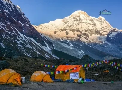
Annapurna Base Camp (4,130 m) : High altitude, breathtaking views
Seeing these numbers on an Annapurna Base Camp trek map helps you understand where rest and caution are most needed.
How Altitude Affects Your Body?
Altitude sickness often happens when you ignore the map and push too fast.An accurate Annapurna base camp trek map helps you:
-
Spot steep altitude jumps
-
Plan gradual climbs
-
Identify safe overnight stops
-
Know when to slow down
As you gain altitude, oxygen levels drop. This affects everyone, even fit trekkers. Common effects include shortness of breath, slow walking speed, headache or poor sleep, and loss of appetite etc. The key is not to rush. A good Annapurna trek map shows gradual ascent, helping you avoid sudden height gain.
Why Acclimatization Matters on the ABC Trek
Acclimatization means giving your body time to adjust to height. On the Annapurna base camp route, this happens naturally if you follow the map properly.
Good acclimatization habits include:
-
Walking slowly at higher altitude
-
Drinking enough water
-
Sleeping lower than your highest point when possible
-
Avoiding long, rushed days
A clear ABC trek map with distance helps you plan shorter days where altitude gain is high.
Local guides from Himalaya Trekking Nepal carefully plan walking hours and rest days to help trekkers adjust safely to altitude.
How to Read an Annapurna Trek Map Properly
Reading a trekking map may look confusing at first, but it is easier than you think. Once you understand the basics, an Annapurna Base Camp trek map becomes a powerful planning tool. It helps you walk with confidence instead of guessing every turn.
In the Himalayas, knowing how to read the map is just as important as strong legs.
Start With the Trail Line, Not the Distance
When you look at an Annapurna trek map, the first thing to notice is the main trail line. This line shows the official trekking path from Pokhara to Annapurna Base Camp. Do not jump straight to kilometers. Instead:
-
Follow the trail direction
-
Notice where the trail goes up or down
-
Check how villages are spaced
Many beginners make the mistake of focusing only on distance. However, the Annapurna base camp trek distance looks small on paper but feels bigger on the ground.
Understand Walking Time vs Kilometers
A good ABC trekking navigation map shows walking time between villages. This is more useful than distance.
For example:
-
5 km on flat land feels easy
-
5 km uphill with stone steps feels hard
This is why experienced trekkers trust walking hours more than numbers. When reading an ABC trek map with distance, always check the estimated walking hours, Altitude gain between stops, and terrain type.
Read Altitude Lines and Height Markers
Altitude lines and numbers are one of the most important parts of an Annapurna base camp map. When reading altitude, you should look for sudden height gain and notice where the trail becomes steeper and identify high sleeping points. For example, the map clearly shows a sharp rise after Chhomrong. Knowing this early helps you save energy and walk slowly. Altitude awareness keeps you safe and confident on the Annapurna base camp route during emergencies.
Identify Villages, Rest Stops, and Tea Houses
Villages on the Annapurna Base Camp trek map are not just names. They are places to eat, sleep, and recover. While reading the map you should mark overnight stops, note lunch villages and check distances between tea houses. This is especially helpful for students and first-time trekkers who want a comfortable pace. Trekking companies like Himalaya Trekking Nepal often use the same map to plan balanced walking days with good rest points.
Look for Rivers, Forests, and Terrain Changes
A good Annapurna trek map shows more than trails. It also shows rivers and bridges, forest sections and open valleys. These details matter. Forest trails feel cooler and easier, while open valleys near base camp feel colder and slower due to wind and altitude.
Check Emergency Exit Routes on the Map
One sign of a good best Annapurna Base Camp trek map is that it shows alternative trails. These routes are useful if someone feels unwell, sudden weather changes etc. Knowing exit routes does not mean you will use them. It simply gives peace of mind.
When you understand your Annapurna Base Camp trek map, you stop worrying and start enjoying the journey. You know what lies ahead, how long the day will be, and when to slow down.
Common Mistakes To Avoid in ABC Trek Without a Map
.A missing or poorly understood Annapurna Base Camp trek map is one of the main reasons trekkers struggle on the trail.
1. Underestimating Walking Time
One of the most common mistakes is trusting kilometers more than hours. On paper, the Annapurna Base Camp trek distance looks manageable. Without a clear ABC trek map with distance and walking time, trekkers often walk too fast at a higher altitude which leads to tired legs, poor sleep, and stress.
2. Ignoring Altitude Gain
Another serious mistake is ignoring altitude shown on the Annapurna base camp map.Some trekkers focus only on reaching the destination. They forget that altitude affects breathing; sleep quality drops at height and energy drains faster. Without understanding altitude points on the Annapurna Base Camp trek map, trekkers may climb too high, too fast. This increases the risk of altitude sickness.
3. Taking the Wrong Side Trails
The Annapurna region has many small paths used by locals, animals, and porters. Without a proper Annapurna trek map, it is easy to take a wrong turn. Common problems include following shortcuts that are steeper, missing the main trail after villages, and wasting energy correcting mistakes.
4. Poor Daily Planning
Without studying the Annapurna Base Camp trek map, trekkers may plan too many hours in one day, Skip good rest villages, and rush near base camp. Good planning means knowing where to stop, not just where to go.
5. Relying Only on Mobile Apps
Technology helps, but it has limits in the mountains. Mobile signal is weak on the ABC trek route from Pokhara onward. Common issues include draining of phone battery, Gps not working, maps failing, etc. This is why printed or offline Annapurna Base Camp trek maps are still trusted by local guides.
Our experienced team at Himalaya Trekking Nepal helps you divide the route into balanced, comfortable walking days.
Explore our more packages in Annapurna Region:
Final Thoughts: Let the Map Lead You, Not Fear
Standing at Annapurna Base Camp is a moment that stays with you for life. But behind every smooth and joyful trek, there is one quiet hero: the Annapurna Base Camp trek map.
When you understand the Annapurna base camp map, you stop worrying about what comes next and start enjoying where you are.The Annapurna base camp trek rewards those who prepare well and walk with care. And preparation begins long before your boots touch the trail.
Whether you are a student trekking for the first time or a traveler returning to the mountains, the right map and the right guidance can turn challenges into memories you will treasure forever.
Take the first smart step today , Plan your Annapurna Base Camp Trek journey with Himalaya Trekking Nepal who know these trails like home.
Walk slowly. Breathe deeply. Trust the map.
The mountains are waiting for you.
FAQ's
How long does it take to trek Annapurna Base Camp?
The Annapurna Base Camp trek usually takes 7 to 12 days, depending on your route, pace, and how well you follow the Annapurna Base Camp trek map.
Which is easier, ABC or EBC?
The Annapurna Base Camp trek is generally easier than EBC because the Annapurna base camp trek distance is shorter, even though it has steeper steps.
Can beginners do Annapurna Base Camp trek?
Yes, beginners can do the Annapurna Base Camp trek by walking slowly and using a clear Annapurna base camp map to plan each day.
Can ABC Trek be done in 5 days?
The ABC trek can be done in 5 days, but it is rushed and safer when planned over more days using an ABC trek map with distance.
What level of fitness is needed for Annapurna Base Camp?
You need moderate fitness, meaning you can walk 5–7 hours a day, which is easier to manage with a proper Annapurna Base Camp trek map.
How difficult is ABC?
The Annapurna Base Camp trek is moderately difficult due to stone steps and altitude, but it is manageable with good planning and an Annapurna trek map.
Do I need a sleeping bag for Annapurna Base Camp trek?
Yes, a sleeping bag is recommended for the Annapurna Base Camp trek because nights are cold at higher altitudes shown on the map.
How many days is ABC?
Most trekkers complete the Annapurna Base Camp trek in 8 to 10 days by following a well-planned Annapurna Base Camp trek map.
Which month is best for ABC trek?
The best months for the Annapurna Base Camp trek are March to May and September to November, when the route shown on the map is safest and clearest.
More About Author

Khilak Budhathoki
Travel Director
Khilak Budhathoki is the co-founder and lead trekking guide at Himalaya Trekking Nepal, a locally owned and operated adventure company based in Kathmandu. Born and raised in the foothills of Nepal, Khilak developed a deep love for the mountains from an early age. With over a deca...
USD$1,400 pp
Our Recommendation

USD$600 pp
Our Recommendation

USD$2000 pp
Our Recommendation
Related Blogs

Feb 08, 2026
Pokhara 2026: Top Attractions & Adventure Tips

Nov 21, 2025
Everest Base Camp Trek Weather: Guide 2026
